In a nutshell
- 🌩️ 2026 likely brings unpredictable summer storms as ENSO shifts and a wavier jet stream toggle the UK between humid troughs and hot ridges.
- 🌊 Elevated North Atlantic marine heatwaves boost moisture and CAPE, priming heavier downpours, training storm lines, and intense microbursts.
- 🌆 City-scale effects: the urban heat island supercharges convection, while drought-to-deluge whiplash drives surface water flooding and runoff spikes.
- 🛰️ Forecasting faces a nowcasting dilemma—street-level specifics hinge on slow-moving cells, convergence zones, and quasi-stationary fronts.
- 🛡️ Practical readiness matters: households, councils, and event planners should prioritise drainage, lightning protocols, and flexible operations to build resilience.
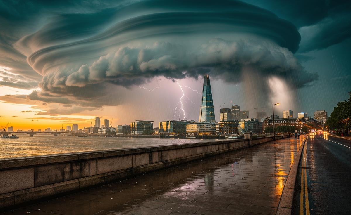
Summer used to be a promise. Long evenings, stable skies, a rhythm you could plan around. That rhythm is faltering. As the Northern Hemisphere edges toward 2026, a tangle of atmospheric drivers points to a season when surprise may be the only constant. Scientists tracking the jet stream, the Atlantic, and the Pacific’s ENSO switchboard see signals that rarely align. Some amplify heat. Others seed storm fuel. The result could be bursts of fierce, short-lived convective weather stitched between heat-laden lulls. For the UK, perched on the Atlantic’s storm belt, that raises a blunt prospect: a summer of unpredictable storms, some disruptive, some dazzling, all demanding attention.
El Niño, La Niña, and a Restless Jet Stream
The Pacific’s push-and-pull — El Niño easing, a possible slide toward La Niña — can ripple across the Atlantic like a drumbeat. When ENSO flips or stalls near neutral, the jet stream often becomes erratic, wobbling north and south, speeding and slackening. That volatility can lock the UK beneath humid troughs one week and under hot, stagnant ridges the next. Small shifts aloft can remake a season. A modest northward kink raises heat and moisture; a sharp dip invites cooler air to collide with warm surface layers. The battleground? Right over our heads.
The North Atlantic Oscillation adds its own mischief. Positive phases can amplify high pressure over Europe, priming heat build-ups. Negative swings can shuttle lows toward the British Isles, with convergence lines that sparkle into evening thunderstorms. Add in Arctic amplification — the pole warming faster than mid-latitudes — and you have a jet stream more sinuous, with quasi-stationary fronts that refuse to budge. That stasis is dangerous. Storms back-build. Cells train over the same postcodes. A single sultry day can end in a deluge, hail clattering like gravel, lightning splitting the twilight sky, and transport networks feeling the strain.
Atlantic Heat and the Storm-Fuelled Sea
The North Atlantic has run unusually warm of late, with patches of marine heatwave conditions feeding moisture into any system that passes. That warmth plumps up precipitable water and raises CAPE, the energy thunderstorms gorge on. Warmer seas mean wetter skies. Even without a tropical cyclone, southerly fetches can tap this moisture and pour it across the UK, especially when a slack pressure gradient allows sea breezes to meet warm inland air. The cocktail is simple: heat at the surface, cooler air aloft, and a trigger like a weak front or sea-breeze convergence. The outcome isn’t simple at all.
| Driver | Signal for 2026 | Storm Implication |
|---|---|---|
| North Atlantic Sea Surface Temperatures | Elevated, patchy heat pockets | More moisture; heavier downpours |
| Jet Stream Position | Wavier, stop–go flow | Slow-moving storm lines |
| ENSO Transition | Potential shift toward La Niña | Increased variability in tracks |
| Subtropical Humidity Feeds | Occasional plume events | Night-time thunderstorms |
Put together, this means rainfall rates that can overwhelm drains in minutes and microbursts capable of toppling branches or scattering outdoor events. Coastal counties may see morning murk explode into afternoon lightning. Inland, elevated terrain can juice lift and turn glowering skies into anvils. The challenge for forecasters isn’t seeing the risk, it’s pinning down the street-by-street specifics hours ahead — a classic nowcasting dilemma in a petrol-soaked atmosphere.
Urban Heat, Drought Flashbacks, and Lightning-Loud Revivals
Cities distort weather. The urban heat island traps warmth, raising night-time temperatures and priming instability for the next day. Stone and asphalt store energy; glass canyons steer winds. A humid plume glancing London, Birmingham, or Manchester will often fire more vigorously than the models suggest. Heat breeds lift; lift breeds storms. When convective cells pop over a hot city, they can pulse repeatedly, each burst wringing another bucket’s worth from the sky. That’s how a “low chance” day turns headline-fast, with power flickers and flooded junctions.
There’s another twist: drought-to-deluge whiplash. After dry spells, soils bake and become hydrophobic. First rain beads and runs, funnelling into culverts and on to streets. The result is amplified runoff and surprise surface flooding, even when totals look modest on paper. Then, as the ground softens, later storms can penetrate deeper and drive saturated-slope landslips. Rural areas aren’t spared. Fields can host fast-flowing sheets of water; small streams can behave like sudden rivers. For transport planners and event organisers, the message is sobering. Storms don’t need to be widespread to be wildly disruptive. One slow-moving cell, over one critical corridor, can be enough.
Forecasting the Unpredictable: What Households and Councils Can Do
In a year skewed toward volatility, strategy beats certainty. Households can prepare for surface water flooding with simple steps: clear gutters, fit air-brick covers, keep a roll of sandbags or flood sacks in the shed. Garden design matters; use permeable paving and rain barrels to shave peak flows from a downpour. Assume surprises are coming. Keep a torch, battery pack, and basic first-aid kit where you can find them in the dark. If you commute, save alternate routes offline and watch live radar on storm-risk afternoons; a twenty-minute delay can dodge a deluge.
Councils and site managers have levers to pull now. Pre-emptive gully cleaning before the first plume event pays dividends. Tree maintenance reduces limb-fall during gust-fronts. Event planners should build in lightning protocols, with evacuation signage and a clear “shelter now” threshold. Emergency teams can lean on nowcasting: blending radar, satellite, and ground observations to make hour-ahead decisions. Businesses can rehearse remote working for the handful of storm days that truly snarl travel. The broader aim is resilience, not prediction perfection — absorbing the hit, keeping people safe, and getting back to normal quickly when the sky flips the switch.
Weather is never static. It’s a living negotiation between oceans, air, and land, and in 2026 the terms may change by the week. Signals point to heat punctuated by sudden, muscular storms, the kind that gild the horizon and then drench the pavement five minutes later. The wise response is vigilance, flexibility, and small acts of preparation that add up when the clouds darken. As we edge into this uncertain summer, what local step — on your street, at your workplace, in your council — could most effectively reduce the sting of an unpredictable storm season?
Did you like it?4.5/5 (20)