In a nutshell
- ❄️ Snow and ice blanket the UK as the Met Office extends alerts into Monday, with amber warnings in parts of Scotland and up to 40cm expected on higher ground (around 5cm in England and Wales).
- 🚦 Major disruption to roads, rail and air, including crashes in Derbyshire, Leicestershire and Nottinghamshire; drivers urged to plan routes, carry essentials, and expect blizzard risks and power cuts in northern areas.
- 🌬️ A surge of Arctic air brings temperatures well below average; forecasters say the cold spell could last well into next week with further wintry hazards likely.
- 🏥 The cold snap pressures the NHS; Health Secretary Wes Streeting urges A&E use only for emergencies as UKHSA warns higher risks of heart attacks, strokes, infections and falls for vulnerable people.
- 🐾 Practical guidance includes how snow forms above 0°C, safe winter driving techniques (leave long stopping distances, clear windows, pack kit), and pet care tips on paws, antifreeze, and keeping small animals warm.
Snow and ice have returned in force across the UK, painting roads, hills and rooftops white and sending temperatures tumbling as Arctic air sweeps south. The Met Office has extended weather warnings into the weekend, with Scotland facing the harshest conditions and parts of England, Wales and Northern Ireland bracing for treacherous surfaces. Travel disruption, slower journeys, and the risk of power cuts are likely for many through the start of 2026. Forecasters say as much as 40cm could fall on higher ground in the north, with several centimetres possible elsewhere. Health officials and ministers are urging caution, especially for older people and those with existing conditions, while road users are told to plan ahead and pack winter essentials.
Where Warnings Are in Force and What to Expect
The most severe amber warnings are concentrated in Scotland, where forecasters flag the potential for blizzard conditions, drifting snow and power cuts. Areas including Angus, Perth and Kinross, Grampian, Aberdeenshire, Moray and parts of the Highlands are on alert, with up to 40cm (15in) possible in places. Elsewhere, widespread yellow warnings for snow and ice are in effect across large parts of England, Wales and Northern Ireland, extending through the weekend and, in some locations, into Monday. Different regions will be affected at different times, so checking the latest local forecast remains essential.
| Region | Warning Level | Expected Snow | Timing | Key Risks |
|---|---|---|---|---|
| Scotland (Angus, Perth & Kinross, Grampian, Aberdeenshire, Moray, Highlands) | Amber | Up to 40cm on higher routes | Active into Saturday midday | Blizzards, drifting, power cuts, stranded vehicles |
| England & Wales | Yellow | As much as 5cm in places | Through weekend; some to Monday | Icy surfaces, travel delays, localised disruption |
| Northern Ireland | Yellow | Snow and ice risk, variable | Through the weekend | Icy stretches, slower journeys |
Forecaster Neil Armstrong said the cold spell “could last well into next week” and “wintry hazards will continue with more weather warnings likely.” That aligns with reports of fresh alerts replacing those initially due to expire on Saturday. In short: expect changeable, occasionally severe conditions, with short-notice updates likely. On the ground, that means slow-going commutes, diversions and delays as crews work to keep roads clear and transport networks moving.
Travel Disruption and the On-the-Ground Picture
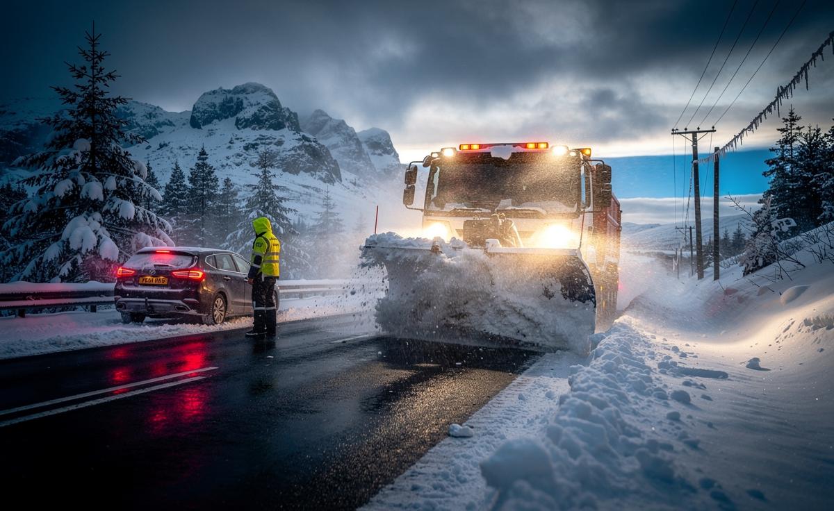
From Wales to Warwickshire and north-east Scotland, scenes of deepening snow have played out since Thursday night. The Horseshoe Pass in Wales required early-morning clearing, while villages in Warwickshire woke to snow-laden rooftops and lanes. In Banchory, Aberdeenshire, some even turned to skis to get around. Scotland’s gritter and snowplough fleet—cheekily named machines like Sir Andy Flurry and Robert Brrrns—has been out in force. Despite those efforts, drivers face hazardous stretches, particularly where compacted snow overlays hidden ice.
National Highways reported multiple crashes in Derbyshire, Leicestershire and Nottinghamshire as conditions deteriorated. Rail and air travellers should anticipate potential delays and cancellations, with knock-on effects likely as crews de-ice and reschedule. For motorists who must travel, plan meticulously and pack essentials: warm layers, water, snacks, a blanket, a phone power bank and an ice-scraper. Keep fuel topped up. Share your route and estimated arrival time. Increase stopping distances substantially, keeping speeds low on inclines and descents. If you encounter drifting snow, do not plough through blindly—turn back safely if unsure. If conditions worsen along your route, consider postponing non-essential journeys until ploughs and gritters have passed.
How Cold Does It Have to Be to Snow?
Colder than average, yes—but not necessarily below 0C at ground level. Snow forms aloft in clouds where temperatures are well below freezing; flakes then fall through layers of air toward the surface. If that air near the ground is marginally above zero yet dry, evaporative cooling can chill it enough to preserve flakes to the surface. This is why snow can fall at 1–2C, especially during heavier bursts. The key factor is the vertical temperature profile and humidity, not just the number on a roadside thermometer.
This week’s setup channels Arctic air across the UK, priming showers to turn wintry, particularly in northern and western uplands and where convection develops in the flow. Elevation and exposure matter: higher routes cool rapidly, allowing snow to settle and drift, while coastal fringes may see wet snow or sleet if sea-modified air raises temperatures a notch. Urban heat islands can also tip the balance to slush, though overnight cooling then refreezes surfaces by morning. When in doubt, assume icy patches—black ice can be invisible yet extremely slick.
How to Drive in Snow and Icy Weather
Preparation comes first. Check the Met Office warnings and live travel updates before setting out. Clear all windows, roof and lights, then use gentle inputs—no harsh steering, braking or acceleration. Leave at least ten times the usual stopping distance on ice. In a manual car, pull away in second gear to reduce wheelspin; in an automatic, use winter mode if available. Keep revs low, build speed gradually, and anticipate hazards early to avoid sudden manoeuvres.
On hills, gain momentum on the flat before the incline, then maintain steady throttle; avoid changing gear on the slope. Descend in a low gear to let engine braking control speed. If you skid, look and steer where you want to go; ease off the pedals until grip returns. If visibility drops or snow starts drifting across lanes, slow right down and be prepared to stop. Pack winter essentials—warm clothing, water, snacks, a blanket, a torch, ice-scraper, de-icer—and keep your phone charged. If travel isn’t essential during an amber warning, the safest choice is often to delay.
How to Look After Dogs, Cats and Other Pets in Cold Weather
Pets feel the chill just as we do. Keep dogs’ walks shorter in bitter winds, and dry coats and paws promptly afterwards. Road salt and grit can irritate paw pads, so wipe them clean and check between toes for compacted snow. Consider a well-fitted coat for small, short-haired or elderly dogs. Cats may prefer staying indoors—ensure they have warm resting spots away from draughts and easy access to litter trays if outdoor toileting becomes difficult. Fresh water is vital; ice can block bowls and pipes.
Antifreeze is highly toxic—store it securely and clean spills immediately. For outdoor small pets, insulate hutches from the ground, add extra bedding and shield from northerly winds; check water bottles for freezing and replace with fresh, unfrozen supplies. Feed at regular times and monitor weight, as some animals burn more energy keeping warm. If your pet shows signs of hypothermia—shivering, lethargy, cold extremities—move them to a warm environment and seek veterinary advice. When temperatures plunge and snow persists, supervised, limited outdoor time is the kindest rule.
The wintry start to 2026 has arrived with force: extended weather warnings, disruptive snowfall, and a biting wind that turns untreated surfaces into glass. Health leaders warn the cold snap will pressure the NHS, so look out for neighbours, keep homes warm where you can, and travel only if necessary. Forecasters suggest the chill could endure into next week, with fresh warnings possible. That means plans may need rethinking, commutes replanning, and wardrobes reshuffled for resilience. As the snow settles and the mercury dips, how ready is your community—and what small steps will you take today to keep one another safe?
Did you like it?4.4/5 (27)