In a nutshell
- 🌥️ Cloud shape is a proxy for stability and lift: steep, cauliflower towers signal high CAPE and strong shear, while flattened layers hint at capping inversions and quieter weather.
- ⛈️ Classic types cue the forecast: cumulonimbus with an anvil means storms; altocumulus castellanus flags later convection; nimbostratus brings steady rain; wispy cirrus foreshadows an approaching front.
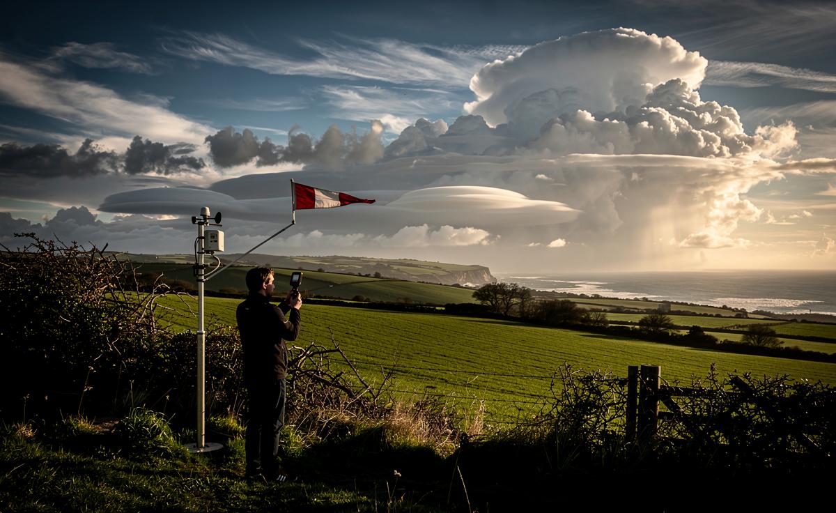
- 🗺️ UK-specific tells: lenticular lenses over Highlands/Pennines imply strong winds aloft; sea-breeze boundaries corral showers inland; onshore North Sea flow breeds low stratus and coastal haar.
- 🧭 Subtle signs matter: sharp vs ragged edges, lowering cloud bases, pileus caps, mammatus, and virga; motion hints from cloud streets and anvil tails pointing along the jet stream.
- 📌 Practical use: treat cloud form as physics made visible, blend with surface data and local topography to time showers, warn of turbulence, and guide decisions—cover the pitch, delay a ferry, pack waterproofs.
Look up and you’re reading tomorrow’s headlines. The shape of clouds is not random fluff; it reflects invisible battles between heat, moisture, and wind. Meteorologists treat the sky as a working diagram of the atmosphere, where bulges, scallops and anvils sketch out stability, shear and lift in real time. In the UK’s maritime climate, these signals can flip quickly as Atlantic lows and sea breezes compete. The art is translating shape into timing: quiet hours, sudden showers, or a full-blooded squall line. With experience, patterns emerge. Crisp towers warn. Flat sheets soothe. Wisps whisper of change. Here’s how the science behind those outlines sharpens the forecast.
Reading the Sky: Why Shape Matters
Clouds are sculptures of buoyancy. A sun-warmed field kicks off rising thermals; where air lifts, it cools and condenses, carving puffs whose outlines mirror the lapse rate. Cauliflower tops imply vigorous ascent; flattened layers betray a stabilising lid. Meteorologists read that geometry as a proxy for energy. Convective Available Potential Energy (CAPE) packs towers high and fast. Weak CAPE smooths tops into humdrum cumulus. In short, sharper vertical shapes point to stronger updrafts and, often, a livelier radar screen later. Wind matters too. Strong shear tilts towers into anvils and blows ice crystals far downwind, marking thunderstorm maturity and steering.
Shapes also trace the engine forcing the air. A gentle, widespread lift from a warm front paints layer cakes of stratus and altostratus, usually hours before steady rain. Localised, punchy lift from surface heating sculpts isolated cumulus, dotted like popcorn over inland Britain by midday. Over hills, orographic lift stacks neat lenses: lenticular clouds aligned with the wind. These forms are more than pretty—each one narrows the forecast. A bulging tower over the Chilterns at 2pm hints at showers by school run; a milky veil sweeping in from the southwest means umbrellas by night.
Classic Cloud Types and the Forecast Clues They Offer
Some shapes are old friends to forecasters. Flat-topped cumulus humilis signal shallow mixing and fair weather. Their beefier cousins, cumulus mediocris, carry upside risk if moisture deepens. The moment cauliflower turrets appear—altocumulus castellanus aloft or towering cumulus below—you’ve got instability with depth, a classic convective trigger. A spreading anvil on a cumulonimbus shouts “storm matured,” its icy fan tracing upper winds. Conversely, dull, featureless nimbostratus equals steady, stratiform rain and poor visibility. High, hairlike cirrus often precede a front by a day, telegraphing change before the ground feels it. Shape is the shorthand; timing and scale come from context.
| Cloud Type | Shape Signal | Forecast Hint | Typical UK Context |
|---|---|---|---|
| Cumulus humilis | Flat, small puffs | Fair, light breezes | Cooler air, weak heating |
| Cumulonimbus | High tower, anvil | Thunder, hail, gusts | Spring/summer convection, fronts |
| Altocumulus castellanus | Turrets at mid-level | Storm risk later | Moist mid-levels, afternoon build |
| Cirrus | Wispy, fibrous streaks | Front approaching | 24–36 hours before rain |
| Nimbostratus | Thick, uniform sheet | Persistent rain/drizzle | Warm-front rainbands |
| Lenticular | Smooth lens, stationary | Strong winds aloft | Lee of Highlands, Pennines |
Even within a type, details adjust the call. Mammatus pouches under an anvil hint at turbulence and severe downdrafts. A pileus cap, a silky hood atop a growing turret, screams rapid ascent. See the cap, expect the tower to keep punching. Watch for virga—rain evaporating before ground—signalling dry lower layers and gusty outflow. Pair these with surface data: a strengthening sea breeze along the south coast can pin showers inland, while onshore North Sea flow breeds low stratus and coastal haar even when inland skies look benign.
Altitude, Edges, and Motion: Subtle Signals Professionals Watch
Forecasters obsess over edges. Knife-sharp cloud boundaries mean dry, stable air adjacent; smeared, ragged edges show mixing and turbulence. When cumulus bases lower and darken in successive scans, moisture is deepening—often the prelude to showers. If tops stop rising and flatten into a table, an inversion has choked the ascent; showers may sputter out. A living edge tells you if the atmosphere is opening the door or slamming it shut. Height layers matter too: stacked decks—stratus below, altocumulus above—imply multiple lifts and a busy day ahead for pilots and planners.
Motion completes the picture. Lines of evenly spaced cumulus, called cloud streets, mark roll convection and brisk low-level winds, a heads-up for choppy crossings in the Channel. An anvil’s feathered tail points along the jet stream, effectively marking storm track. Stationary lenticular clouds over the Lakes betray mountain waves and potential severe turbulence, even on “clear” days. Scudding, low fragments racing beneath a higher deck speak of strong gust fronts. Spot altostratus thickening and lowering through the afternoon across western Scotland? That usually means the warm conveyor of an Atlantic system is on schedule, with rain bands queueing behind. When shape, height, and motion align, confidence rises sharply.
The weather is a storyteller, and clouds are its punctuation marks. By treating shape as physics made visible—updrafts, shear, stability—we convert fleeting outlines into practical forecasts: when to cover the pitch, delay a ferry, or pack the waterproofs. The method is teachable: look for edges, watch for growth, note alignment with wind. Pair that with local knowledge of Britain’s coasts and hills and you’ll anticipate many “surprises.” The next time you step outside, what do those towers, veils, and lenses say about your next six hours—and what will you do with that knowledge?
Did you like it?4.4/5 (27)