In a nutshell
- 🌧️ Seasonal drivers: a tilt toward La Niña, the volatile NAO, and warm SSTs load the dice for gusty, wet spells; treat the 24–48 hour window as the sharpest forecast lead time.
- 🌀 Storm tracks: a vigorous jet stream favours Atlantic lows targeting western coasts, with surface-water flooding in cities and upland snow; watch estuaries during spring tides.
- 🧰 Preparedness that works: clear gutters, secure furniture, sign up for flood warnings; understand the Pros vs. Cons of sandbags, generators, travel curbs, and social media alerts.
- 🔌 Disruption management: local grid faults, rail speed limits, and flight adjustments are likely; register on the Priority Services Register and strengthen community resilience via neighbour networks.
- 🌊 Bottom line: not uniformly wild, but expect punchy Atlantic spells and flood-prone interludes—prioritise readiness over certainty with simple, rehearsed plans.
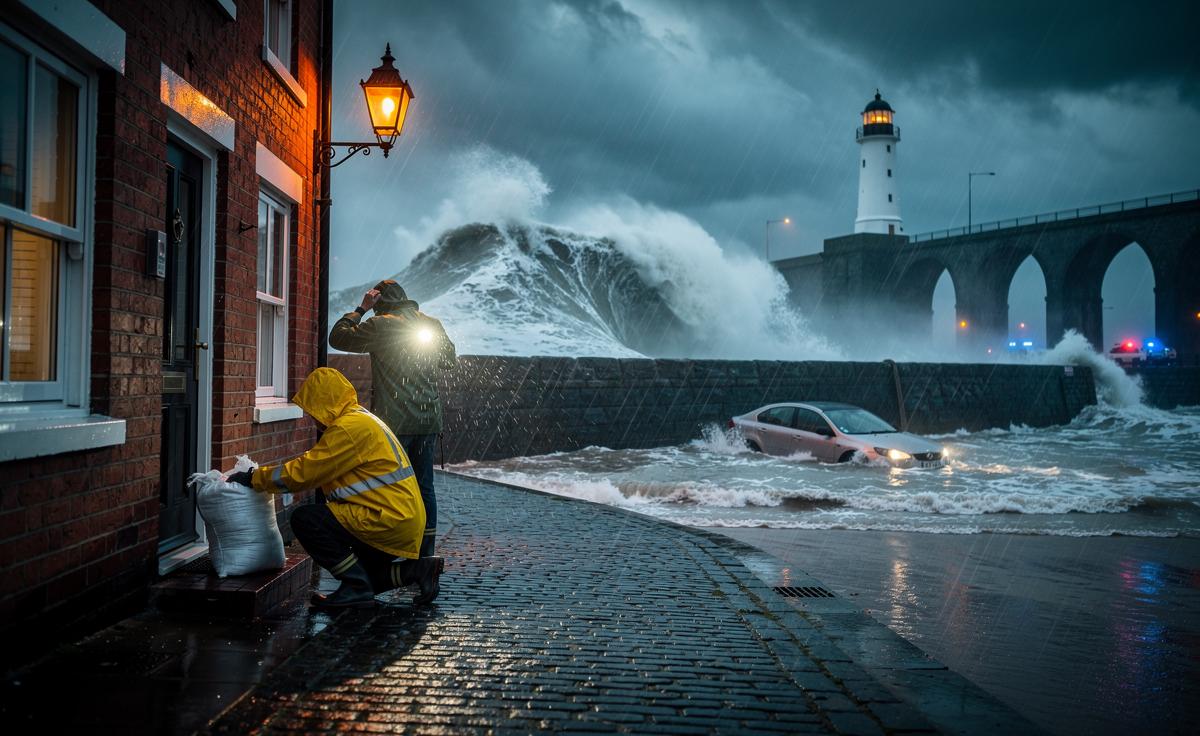
Britain’s winter storms have a rhythm all their own, pulsing with the Atlantic’s mood, sharp temperature contrasts, and the fickle path of the jet stream. This year, forecasters flag a familiar mix: fast-moving lows, short-notice wind warnings, and spells of intense rain broken by calmer interludes that can turn icy overnight. Winter 2026 is poised to be a season of contrasts—milder air at sea level colliding with wintry outbreaks over higher ground and northern counties. The headline for households is simple: short, disruptive bursts are likely, and preparation will be worth more than prediction. As ever, the story varies by region, with western coasts facing gales and inland areas watching rivers and saturated soils.
Signals Shaping the Season
Several large-scale climate signals will guide the UK’s storminess. A tilt toward La Niña conditions in the Pacific tends to nudge the jet stream and can encourage sharper temperature gradients across the Atlantic. The North Atlantic Oscillation (NAO) remains the wildcard: a positive phase often favours milder, wetter westerlies; a negative phase can unlock colder, blocked patterns. Sea-surface temperatures in the North Atlantic remain elevated relative to the late-20th-century average, priming extra moisture for rain bands. None of these guarantees a specific storm track, but together they load the dice for gusty spells and surface-water flooding.
Here’s a concise read of the season’s steering factors and what they usually imply for the UK:
| Signal | Typical UK Impact | Confidence |
|---|---|---|
| La Niña Tilt | Stronger polar contrasts; potential for lively Atlantic lows | Moderate |
| NAO Phase | +NAO: Wet/windy; −NAO: Colder, drier spells with snow risk north | Low–Moderate |
| Warm SSTs | Enhanced rainfall rates in frontal systems | High |
| Polar Vortex Health | Stable vortex: Atlantic flow; disrupted vortex: cold snaps | Low |
Expect ebb-and-flow rather than a single dominating pattern—brief calm, then sudden warnings. For planning, this means checking daily updates from the Met Office and treating lead times of 24–48 hours as the window where forecasts sharpen.
Storm Tracks, Wind Risk, and Flood Hotspots
Atlantic storms typically ride a barrelling jet stream across Ireland and into the Irish Sea, curving into northern England and southern Scotland. That track exposes western coasts—from Cornwall and Pembrokeshire to Cumbria—to the brunt of the gales, while converging fronts spill heavy rain inland. Short, intense bursts of rainfall are increasingly the trigger for surface-water flooding, especially in urban catchments with limited drainage capacity. On high ground in the Pennines, Snowdonia, and the Highlands, marginal setups turn to sleet and snow, stranding remote roads even as lowland cities stay wet and windy.
My field notebook from a late-January gale captures the pattern: gusts snapped branches onto railway lines near Gargrave, while downstream villages on the Aire watched levels creep up, not catastrophically, but uncomfortably fast. The same story repeats along the Severn and the Ouse after two back-to-back lows. Named storms make headlines, yet it’s the “ordinary” depressions—fast, poorly named, soon forgotten—that saturate soils and set the stage for the next flood surge.
Watch points this winter include estuaries with spring tides (Bristol Channel, Mersey) where onshore winds can stack water. Urban flash-flood risk remains elevated around hard surfaces and older Victorian drains. Coastal routes and exposed bridges may see short-notice closures even when inland areas feel merely blustery.
Preparedness That Actually Works (and What Doesn’t)
Preparation isn’t about stockpiling gadgets; it’s about knowing what fails first. Most storm damage stems from predictable weak points: unsecured roofs, blocked gullies, and items turned into missiles by 60–70 mph gusts. I’ve seen terraced streets in South Wales escape flooding thanks to a single neighbour clearing leaves from grates each evening during a wet week—small acts with outsized effect. At a farmhouse in Northumberland, a £30 downpipe diverter spared a stone-walled kitchen when rain came sideways for six hours.
Pros vs. Cons
- Sandbags: Useful for shallow, slow-onset seepage; Not a cure-all for fast-moving surface water. They can leak and are heavy to deploy.
- Generators: Keep fridges and medical kit powered; Downside is carbon monoxide risk—never indoors—and fuel storage rules.
- Travel Bans: Reduce casualties during peak gusts; But can strand key staff if timed too broadly or too early.
- Social Media Alerts: Fast and local; However, rumours spread—verify via Met Office and Floodline.
Quick wins that pay off:
- Clear gutters, check roof tiles, and secure garden furniture—classic, because it works.
- Map your nearest sand and grit bins; pack a car kit: torch, blanket, phone power bank, high-energy snacks.
- Sign up for flood warnings and know the difference between Alert, Warning, and Severe Warning.
Preparation beats heroics: ten minutes today can save a weekend of mopping tomorrow.
Energy, Travel, and Community Resilience
Energy demand spikes on cold, windy days, and while the UK’s grid is engineered with margin, local faults from flying debris are what cut power. Keep a list of essential contacts and a charged battery pack; for medically dependent equipment, ask your supplier about the Priority Services Register. Rail passengers should expect precautionary speed limits on exposed lines and intermittent closures for fallen trees; airlines will manage crosswind limits, sometimes shifting flights rather than canceling outright. Build slack into itineraries—winter journeys are about resilience, not speed.
Community matters. In Hebden Bridge, a volunteer “flood warden” text group now beats sirens to the punch with hyperlocal updates. In coastal Dorset, a WhatsApp chain ensured two isolated residents had hot food during a 12-hour outage. These networks don’t replace official warnings, but they close the gap between information and action. For homeowners, photograph possessions for insurance; keep serial numbers and policy details backed up in the cloud. Businesses should test remote-work failovers and protect stock off the floor by at least one pallet’s height.
Resilience isn’t a bunker; it’s a living plan shared with neighbours, colleagues, and family.
Winter 2026 is unlikely to be uniformly wild, but the ingredients are there for punchy Atlantic spells, sharp wind events, and flood-prone interludes—especially where soils are already wet. Staying weather-literate, practising small prevention steps, and leaning on community ties will matter as much as any forecast map. Don’t chase certainty; chase readiness, and trust the daily updates over long-shot seasonal narratives. The UK handles storms best when plans are simple and rehearsed. What will you put in place this week—at home, at work, and on your street—to make the next weather warning a manageable inconvenience rather than a crisis?
Did you like it?4.6/5 (20)